Description Notes Maps Web References
| Difficulty: | Intermediate |
| Length: | 18 miles |
| Water: | Treat water from Turkey creek or tank at road crossings |
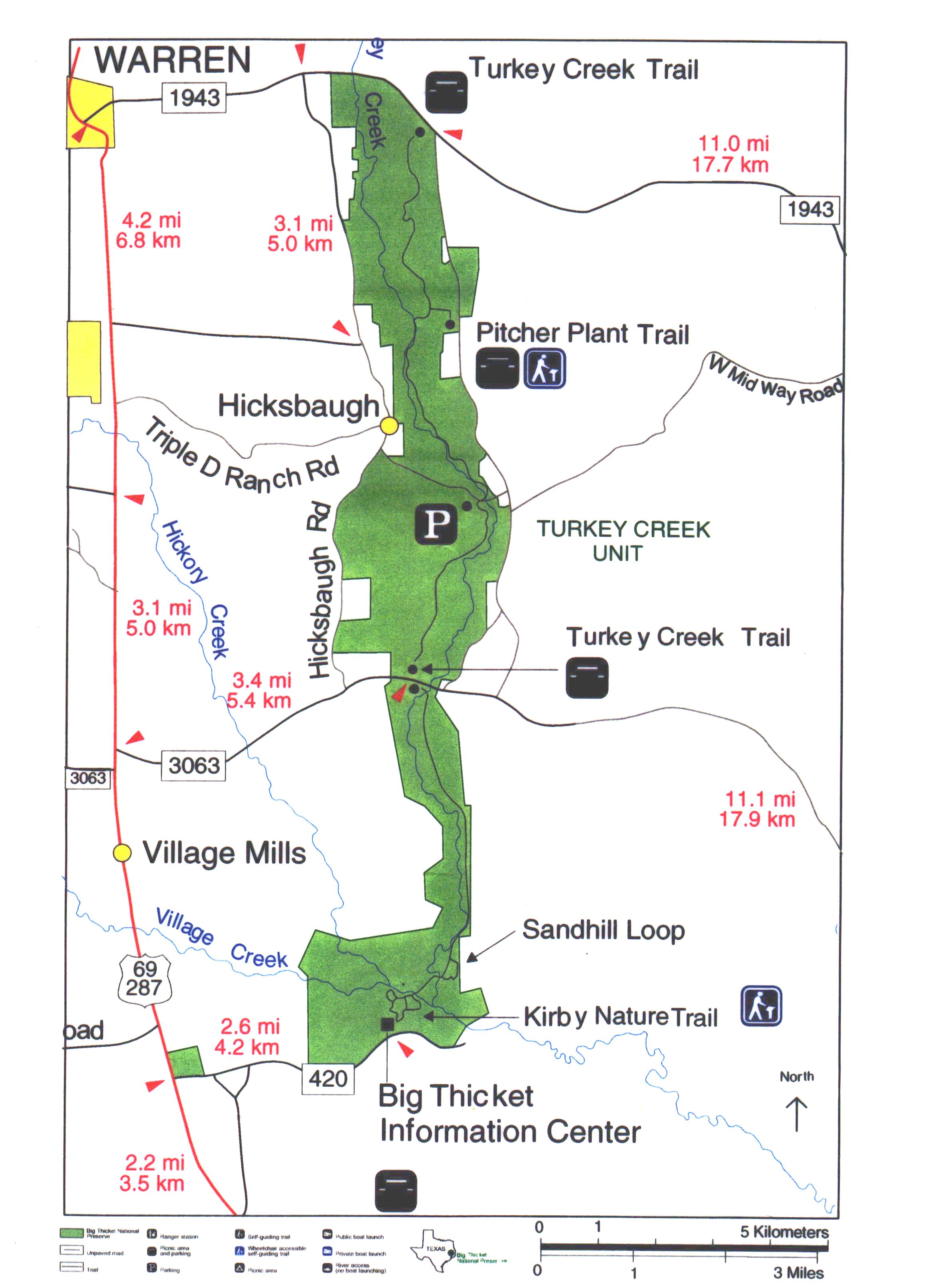
The Turkey Creek trail runs north south in the Turkey Creek unit of the Big Thicket Preserve north of Beaumont. The trail parallels Turkey Creek and is one of the longest in the Preserve. Access to the trail and water drops can be made at four separate trailheads dispersed from north to south. There is no easy to find camping spots for a late Friday arrival so begin most treks early Saturday. Along the trail, diverse views of sandy pine uplands, mixed forests, floodplains, and baygalls can be found along Turkey Creek. Feral pigs are common and as such the population of mountain lion has shown resurgence. If you are one of the fortunate few to get a glimpse of these recluse creatures, be sure to report it on your exit. A permit is required and must be displayed for overnight use. Contact the information center (located at the southern end of the trail) at 409-246-2337. You are required to report your entry and exit from the unit. Park policy states that failing to report your departure will cause your being billed for search and rescue. Logistics for scout groups can be difficult for this trek. The preserve requests that groups be no larger than eight per crew. Considering the two adult minimum per crew, this can be challenging. They are willing to make some exceptions (perhaps up to ten or twelve) for sponsored groups. Trail is very well marked, wide and bridged.
Trip Dates: Sep 2000
This is a great trail in Southeast Texas Big Thicket! We set out early Saturday morning and drove to the Big Thicket Information Center along rt. 420. Here we divided up our crews into 3 small groups as required by the park authorities (max crew size is nine). We sent one crew to the north end to begin their southerly trek from the trailhead along 1943 west of Warren while a second crew scouts started the northerly trek. Additionally, the first year scouts set out to the 3063 trailhead for a nine mile hike north to 1943 trailhead. We left about 20 gallons of water in the first year scout’s car at 3063 crossing for the two thru-hiker crews to tank up along the way. All the crews had a great time. The first year crew encountered a sow feral pig and her piglets near the Pitcher Plant Trail. Fortunately she led her little ones away and did not display aggression as is so common with these beasts. Near the mid-point of the trail, the two thru-hiker crews met and had a rest break to share some war stories. After everyone practiced their LNT skills camping that evening – from licking bowls to cat holes, we rose early to complete the trek. After checking in with the Info Center to sign out (required) we headed for home around noon. This is a great trail, well-marked and easy to follow – definitely worth a visit!
From the Woodlands: Take 242 East to 59 North to Cleveland. Then 105 East to Batson. Just past Batson, take 770 North. 770 ends at the junction with 326 make left and head toward Koonce. In Koonce, take 69 North. Look for the Big Thicket Information Center signs on your right about 3 miles south of Village Mills on rt 420. The trailhead is located at the old information center about 2 miles from the 69 junction. There is plenty of parking. Use the overview map provided to locate the other trail crossings. Remember the law requires that you obtain a permit, keep small groups (8 or less) and check in and out at the Info center – or by phone on exit.
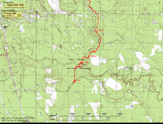
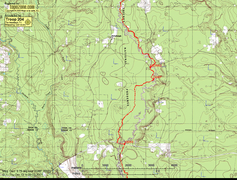
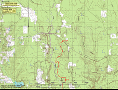
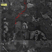
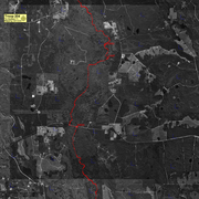
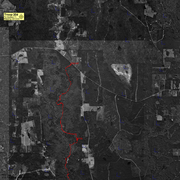
We have a GPS trace on the Topozone.com map made by Troop 204 mapping services. See the overview map. Thanks, Peter. Click on a section of the overview below to see the full size map.
http://www.lib.utexas.edu/maps/national_parks/bigthicket_park97.pdf
http://www.nps.gov/bith/trails.htm