Description Notes Maps Web References
| Difficulty: | Intermediate |
| Length: | Various |
| Water: | Tank along the way |
The Four C National Recreation Trail leads hikers through
part of the Davy Crockett National Forest. This 20-mile-long trail begins at
Ratcliff Lake Recreation Area and ends at the Neches Bluff Overlook.
Named for
the Central Coal and Coke Company, which logged virgin timber in the area, the
Four C Trail follows some abandoned tramways built by that company. The area
around the trail is a forest that grew after the company completed its logging
operation in the early 1920's. Its sawmill was located at Ratcliff Lake, which
served as a log pond. Ratcliff Lake is now a developed recreation area with paid
camping and facilities and paid parking (honor system).
Except for a 1-mile segment through privately owned timberlands, the Four
C Trail stays on national forest land. The trail, marked with white rectangular
tags on trees, is easy to follow. The hiker may enjoy a variety of aesthetic and
educational experiences through pines, bottomland hardwoods, boggy sloughs, and
upland forests. Both old and young trees representing second-and third-growth
forests grow along the trail. After
a 2 hour drive from Houston, Friday evening camping is available at the grassy
parking area at Naches Bluff. A
primitive AT style lean-too is located at the Walnut Creek campsite mid-way
along the trail. Water can be
tanked near this road crossing (513-2).
Early April - 2001:
This is a great trail! We took 2 days to complete the 20 miles. After driving up late afternoon on Friday, we arrived at Ratcliff Lake at 7:30PM
where we left one vehicle (parking fee $3.00 per night - honor system). We then followed along the dirt county and forest roads (see overview map) to
the trail crossing at Walnut Creek and rt. 511 where we left a second car with 10 gallons of water. Finally we reached Nachez Bluff by about 9:00PM
and camped at the trail head (plenty of room). The start of the trek has some great topography, with the trail scooting along the bluff gradually
winding down to the Nachez River. Here the trail follows an old road for
about a mile where it finally breaks to the west into the forest. Much of the trail follows the old tram lines now only discernible as linear graded
mounds in the low areas and cuts through the higher ground. This makes for an interesting contrast to the rolling forest around you. The midpoint of the trail has a well maintained "AT style" lean to, complete with privy.
Remember this in the event you get hit with a nasty storm! This would have been a great overnight spot, but we elected to push on to shorten the next day's hike. After tanking up our water supply at the Walnut Creek/511
crossing, we made camp on a hill top just prior to the 517 trail crossing
at the Hickory Creek bridge (see overview map). We had a textbook Leave No Trace mound fire using a pile of sand that had been burrowed out by some
busy critter on the edge of our campsite (see Photo). The next morning,
we crossed the Big Slough Wilderness Area. Clearly the trail crews had been busy, the extensive board walks over the swamp are impressive.
Emerging from the slough the trail crosses some old farm land, now slowly
recovering into a forest waist-chest high. Finally we wound our way to Ratcliff Lake and met the car by noon. The trail is very well maintained
with bridges over most larger creeks and very well marked. Certainly one of the best trails around the Houston area.
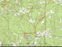
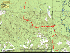
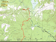
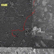
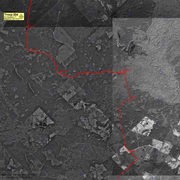
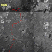
These maps were made from a trace of GPS coordinates.
Click on a section of the overview below to see the full size map.
Driving time from The Woodlands - approximately 2
hours to Ratcliff Lake.
Take I45 North through Huntsville to Madisonville. Then SH 21 East to
Crocket. In Crocket take loop 304 South to SH 7 East (toward Lufkin).
Ratcliff Lake National Recreational Area is located on your left inside
Davy Crocket National Forest. Follow the overview map for the forest
service and county roads to locate the trail crossings at Walnut Creek (if
you elect to tank water) and the trail head at Nachez Bluff.
Special Note: The County has taken over many of the old forest service
roads in Davy Crocket National Forest and in doing so changed the numbering
along many of them. If you carefully monitor your progress with the map,
finding the trail crossings, even in new moon darkness was not difficult -
just don't trust the road number signs!
Trails.com
http://www.r8web.com/texas/Recreation/Davy%20Crockett/four_c_hiking_trail.htm