| Difficulty: | Intermediate |
| Length: | ~ 16 km, two days, one night |
| Water: | Treat Boswell Creek |
The Four Notch Loop is a side loop of the Lone Star Trail just south of Huntsville, TX Four Notch Loop is located just Northwest of New Weaverly off of I45. Parking lot is large and grassy and offers a great spot to camp on Friday night if you arrive after dark. Trail is approximately 10 miles in length and very well marked. Ample water supply when treated or boiled is available from Boswell Creek. Boswell Creek also offers deep wading to cool off in the warmer months. Since no bridges ford the streams, when water is high scouts are offered the unique opportunity to find the best ways to cross a river. The Four Notch area was devastated by the Pine Bark Beetle in the early 80’s. This trail loops through the secondary growth forest that was replanted by the Forest Service in 1982. The trip offers an excellent opportunity to observe the reforestation process nearly 20 years after the disaster. The forest is now heavily covered in dense vegetation and should be an enlightening experience. A careful observer can detect the transition from wilderness to secondary growth forest.
Trip Dates: weekend in March 2000
We started Saturday morning from the parking lot near mile 45 of the Lone Star Trail. It is just a few minutes to the loop turnoff. We hiked just over half the trail clockwise. If you are on the north side of the loop and find a campsite, take it. There is a lot of thicket there and not many places to camp. .
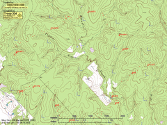
We recorded GPS lat-long coordinates of the mile markers along the trail.
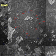
Click on a section of the overview below to see the full size map.